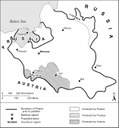
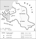
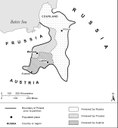
Maps of the three partitions of Poland in the 18th century
The partition of 1772:
The partition of 1793:
The partition of 1795:
Please click on the maps to enlarge the picture.
The three partitions of Poland, maps, 1992, Federal Research Division of the Library of Congress; source: Glenn E. Curtis and Library Of Congress, Federal Research Division: Poland: A Country Study, Washington, D.C. 1994, digital copy: https://www.loc.gov/item/93046235/, public domain.


