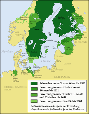
Development of the Swedish Empire within Early Modern Europe (1560–1815)
This map shows the development of the Swedish Empire in the early modern era. It depicts territorial boundaries under the rule of Gustav Vasa (Gustav I, 1496–1560) up to 1560, following his sons' acquisitions up to 1611, under Gustavus Adolphus (Gustav II Adolf, 1594–1632) and his daughter Christina (1626–1689) up to 1654 as well as those of Charles X Gustav (1622–1660) up to 1660. The last of these posessions to be lost was Stralsund, ceded to Prussia 1815.
Development of the Swedish Empire within early modern Europe (1560–1815), map, 2008, author: Memnon335bc; source: Wikimedia Commons, https://commons.wikimedia.org/wiki/File:Ortus-imperii-suecorum.png, Attribution 3.0 Unported (CC BY 3.0) https://creativecommons.org/licenses/by/3.0/deed.de.
