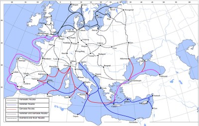
Trade routes in the late Middle Ages

The map shows several main trade routes in late medieval Europe. In the North Sea and Baltic region, these include the routes of the Hanseatic League (black), in the Mediterranean region the trade routes of Genoa (red) and Venice (blue) and routes that were used by both Genoa and Venice (purple). The dotted lines mark overland routes and waterways.
Trade routes in the late Middle Ages, digital map, 2008, creator: Lampman; source: Wikimedia Commons, https://commons.wikimedia.org/wiki/File:Late_Medieval_Trade_Routes.jpg, public domain.