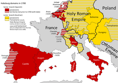
Map of the Habsburg dominions in 1700

This map shows the Habsburg dominions in 1700. A striking feature is the so-called “Habsburg embrace”, which meant that France found itself situated between the territories of the House of Austria in the Iberian Peninsula to the south and its possessions in the Low Countries to the north. The Holy Roman Empire to the east, moreover, was ruled by a Habsburg emperor.
Map of Habsburg dominions in 1700, map, 2013, author: Alphathon; source: Wikimedia Commons, https://commons.wikimedia.org/wiki/File:Habsburg_dominions_1700.png, Attribution-ShareAlike 3.0 Unported (CC BY-SA 3.0) https://creativecommons.org/licenses/by-sa/3.0/deed.de.